
Author: adminMaPP
Regional RMAC Meeting #6 – June 9, 2014
Regional RMAC Meeting #5 – April 29, 2014
North Vancouver Island MPAC Meeting #10 – June 5-6, 2014
MaPP progress update – extended to October 2014
The Marine Plan Partnership for the North Pacific Coast (MaPP) is an ambitious initiative with many significant outcomes. To date, the MaPP initiative has developed four sub-regional draft marine plans, three of which have completed public input periods. These are the Haida Gwaii, North Vancouver Island and North Coast sub-regional draft plans. The Central Coast draft Marine Plan is currently accepting public comments until July 11, 2014. The MaPP initiative is also in the process of completing a draft regional priorities plan, with a target date of August 2014.
In order to achieve these remaining outcomes, prepare for final sign-off of the plans by the partners and transition to the implementation phase, the completion date for the MaPP initiative has been extended to October 31, 2014. This extension will be accommodated within the original budget.
Once completed, the four MaPP sub-regional marine plans and the regional priorities plan will provide recommendations on marine uses and activities, marine protection and other key areas of marine management to inform decisions regarding the stewardship of British Columbia’s marine environment.
The MaPP Working Group appreciates the scope and complexity of the MaPP planning work and the stakeholder engagement accomplished to date. We are grateful to the advisory committee members, stakeholders, partners, supporters and the MaPP planning teams for their continued commitment to the MaPP initiative and its successful completion.
MaPP Marine Working Group
R. Mervyn Child – Nanwakolas Council
Robert Grodecki – North Coast-Skeena First Nations Stewardship Society
Allan Lidstone – Government of British Columbia, Ministry of Forests, Lands and Natural Resource Operations
Trevor Russ – Council of the Haida Nation
Doug Neasloss – Central Coast Indigenous Resource Alliance
Garry Wouters – Coastal First Nations-Great Bear Initiative
MaPP public review update – Comments now welcome on Central Coast Plan
The Central Coast draft Marine Plan is now available for public review and comment. To review the draft plan, learn about community meetings in Bella Coola and Shearwater and provide comments, please visit Central Coast Draft Plan for Input. The public review period runs to July 11, 2014.
The MaPP team extends thanks to all who participated in the public review of the North Vancouver Island, Haida Gwaii and North Coast draft Marine Plans. The public consultation periods for these three sub-regions are now closed.
More than 300 people have attended public meetings to date. In April, three public meetings were held on Vancouver Island and four on Haida Gwaii, in addition to meetings with interested stakeholder groups. Two North Coast public meetings were held in mid-May and two Central Coast meetings will take place on June 16 (Bella Coola) and June 18 (Shearwater). Participants who are unable to attend the Central Coast meetings or have comments on the Central Coast draft Marine Plan can provide input via online response forms, email and mail. Learn more.
Following the public and stakeholder consultation processes, sub-regional planning teams will review all the feedback and make changes to the plans where appropriate. The comments received from the public review have been documented, and a summary of the main themes of the comments will be made available on the MaPP website following completion of the final plan documents.
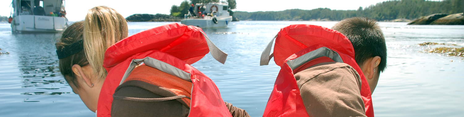
Building emergency response capacity in coastal communities
 It’s hard to plan for something you hope will never happen, and yet being prepared for a crisis increases the chances of managing an emergency efficiently and equitably.
Today on the coast there is significant marine traffic, and with that traffic come risks. Yet at the same time, this traffic helps generate economic activity and jobs up and down the coast. It is critical to ensure that this traffic stays safe and that there are plans in place should an accident happen.
For coastal communities, one way of getting prepared could mean developing a geographic response plan (GRP) – a plan that can kick into action within the first hours of an incident, often well before emergency response agencies can get to the scene. GRPs consider the multiple priorities of coastal communities – social, cultural, ecological, and economic.
Because GRPs pre-identify priorities such as areas for protection, location of human and equipment resources, and places of refuge for troubled vessels, they can accelerate response time and help to reduce the threat and impacts of an incident.
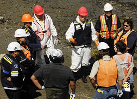
One deliverable of the MaPP initiative is to help communities in the MaPP study area understand and define the nature and scope of GRPs. The initiative has contracted environmental emergency response planner Stafford Reid to begin the work. “Geographic response plans are part of coastal planning management – a tool for managing the impacts from all types of vessels and all types of cargo,” Reid says.
The tough work in emergency response planning is determining the priorities for first responders. What gets first attention – a cultural heritage site, environmentally sensitive habitat, or a business? The process needs to be collaborative, transparent and considerate of diverse possibilities, since trade-offs are inevitable and difficult decisions have to be made. And in the moment of a crisis, there is little time for discussion.
Graham Knox, director of the Environmental Emergencies Program with the B.C. Ministry of Environment, says, “If we can do this sort of work up front, then the first responders can hit the ground running in that first 24- to 48-hour period, while the cavalry gets mustered and until the Incident Command Post and the incident management teams are in place.”
The Incident Command Post integrates many response teams, including Canadian Coast Guard, Fisheries and Oceans Canada, Environment Canada, Ministry of Environment, First Nations and local government, as well as the ship owner and its contracted response organization.
“In the field of emergency management, all emergencies start at the local level. So, it’s critical that local people are engaged and included in all phases of preparedness through response and recovery,” Knox says. “First Nations and other people living in the coastal communities have a lot of information that more centralized agencies may not have.”
GRPs, which are well developed in the United States, have evolved from hard-copy documents to web-based, multi-media applications that include geographic information systems, databases, documents, images and videos. GRP design and development is new to Canada.
The MaPP initiative has compiled a suite of studies and datasets that could support GRP development, not to mention the wealth of on-the-ground knowledge and expertise in coastal communities. In addition to the draft marine plans, MaPP resources include traditional, local and scientific knowledge, technical expertise and mapping/planning tools such as the marine planning portal with over 300 data layers.
MaPP participates in 2014 Salish Sea Ecosystem Conference
MaPP marine coordination team members Charlie Short (Province of B.C.) and John Bones (Nanwakolas Council) represented MaPP at the Salish Sea Ecosystem Conference in Seattle from April 30-May 2, 2014. MaPP science advisor Jo Smith and indicators consultant Andrew Day joined them to present on three topics:
- A collaborative approach to systematic marine protected area network planning in British Columbia.
- Implementing ecosystem-based management in Canada’s Pacific: developing a marine zoning framework.
- Marine protected area design for the North Pacific Coast, Canada.
About the conference Short said, “I was amazed at the amount of restoration research and rehabilitation the Salish Sea ecosystem is undergoing – something we just don’t see in the North Coast of B.C. It reinforced some of the reasons why we do comprehensive resource planning – to avoid costly restoration and remediation efforts in the future.”
Bones observed that in addition to contributing topic-specific presentations, the MaPP initiative reinforced the uniqueness of the MaPP governance structure. “MaPP is such a comprehensive and all-encompassing ecosystem-based management process that it brought a new model of coordinated effort to conference participants,” he said.
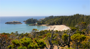
Dive sites
There are 266 dive sites identified in the MaPP study area
Putting diving on the MaPP map
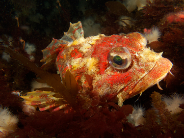
A Red Irish Lord at Browning Pass
A rock wall in the waters off the Northern tip of Vancouver Island is world famous – at least to a select group of people in dry suits. Scuba divers come from all over the world to dive the wall at Browning Pass and other remarkable sites near Port Hardy.
Browning wall is a sheer rock face, about a block long that starts some 30 metres above the water line and plunges steeply to a boulder-strewn sea floor at about 40 metres deep. It is densely populated and teeming with marine life. “You could spend 50 minutes underwater just looking at one metre square,” diving enthusiast Gary Marcuse says. “The more you look, the more you realize there are layers of plants and animals and tiny little fish.”
Scuba Diving Magazine Divers’ Choice Awards has consistently ranked British Columbia as a top diving destination in North America. “The more I was diving elsewhere in the world, the more I realized that right in our back yard, in the Queen Charlotte Sound area, we have this extraordinary collection of mini ecosystems,“ Marcuse says.
Back in October 2012, Marcuse was overnighting in a hotel in Port Hardy before catching a boat to a dive location. He was lured into a meeting room by a plate of cookies and walls covered by maps. He had happened upon the first open house for the MaPP North Vancouver Island sub-region.
In addition to being an avid recreational diver, Marcuse is a documentary film and television producer. However, it was his master’s degree in regional environmental planning that drew him to the marine planning maps and he quickly said, “Where are the dive sites?”
That question eventually led him and Paul Sim of the Underwater Council of BC (UCBC) to Alan Thomson and Nick Heath, the public recreation representatives on the North Vancouver Island (NVI) Marine Plan Advisory Committee.
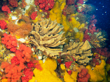
Glove sponges and soft red corals at Browning Pass
Thomson saw that Marcuse offered both a planning background and connections to the diving community through UCBC, a non-profit society that provides a voice for B.C. recreational divers and promotes safe scuba diving and environmental protection. Using advisory committee support funds, Thomson arranged a modest consulting fee for Marcuse to develop a report that identified more than 120 dive sites in the NVI sub-region and more in the Haida Gwaii sub-region. In addition, other divers contributed stunning video and photographs.
Marcuse recorded his dive site information in the BC Marine Conservation Analysis (BCMCA) database, which more than doubled the dive sites included in the database at that time. The BCMCA is one of many data sources for the MaPP marine planning portal, a sophisticated planning tool that allows users to look at many different data layers together to learn more about the MaPP study area.
Thomson says that without the report from Marcuse and the UCBC, there would be less information about diving in the NVI Draft Marine Plan. “So I think their report added depth and scope to the draft marine plan and also added information to databases such as the BCMCA.” He adds, “Mustering the facts and providing them in their report can only help to put recreational diving on the map and inform decision-makers about the possible consequences of choosing one course over another.”
“I like to think of divers as explorers in the marine ecosystems,” Marcuse says. “Divers are putting red flags on the map wherever they discover vital and abundant life.”
Kelp
The oldest known kelp, Pterygophora californica, is about 29 years old and looks like an underwater palm tree.
The Hakai Program brings together big minds to answer big questions
West shore of Calvert Island
We know a lot about forests and the important role they play in our environment and our economy. But what do we know about underwater forests – the nutrient-rich kelp forests found along the North Pacific Coast?
Applied marine ecologist Anne Salomon, who studies kelp forests, calls them one of the most productive ecosystems on our planet. They provide habitat for rockfish, abalone, sea urchins and many more marine species. Kelp forests are also a source of food that fuels marine food webs and they help to calm the waters on wave-exposed outer shores, providing a safe haven or nursery for tiny larvae, fish and shellfish.
“They also sequester carbon dioxide, so they’re carbon sinks,” Salomon says. “That’s a pretty important service these days given that we have too much carbon in our atmosphere.”
Salomon is an assistant professor at Simon Fraser University in the School of Resource and Environmental Management and a member of the MaPP Central Coast Marine Plan Advisory Committee. She is also one of the principal investigators of the Hakai Network for Coastal People, Ecosystems and Management. Housed at SFU, it is a network of Canadian and international scientists that works with the Hakai Beach Institute on Calvert Island off the central coast of British Columbia.
Hakai and its funding body, the Tula Foundation, are the brainchildren of Eric Peterson and his wife, Christina Munck. A fourth generation British Columbian, Peterson is an early-stage entrepreneur who thinks long-term. He is a geneticist and molecular biologist who is used to examining things in detail. He is a former McGill University professor who worked in B.C.’s coastal resource industries in his student years. He is also a successful tech entrepreneur who sold his commercial interests to establish the Tula Foundation.
The Tula Foundation finances and runs the Hakai Program, a set of interlocking initiatives in ecological research and education that concentrate on coastal margins and the watersheds and estuaries that feed them. The Hakai Program focuses on long-term ecological research, which Peterson describes as, “Choose a region, study it long-term, study it year round, and study lots of factors and their interaction.”
Peterson’s commitment to long-term research is valued by scientists who often are funded for shorter time spans. “It’s a huge amount of foresight to provide long-term funding because you can only detect change with long-term monitoring … we need data that go through time,” Salomon says.
She adds that the type of data collection that Peterson helps to fund through the Hakai Beach Institute over time will assist scientists in assessing the effects of initiatives such as MaPP.
Recently, Salomon and a number of other scientists launched the Outer Shores Research Program. Funded by the Tula Foundation, the program works in collaboration with the Hakai Beach Institute and Central Coast First Nations, including the Heiltsuk and the Wuikinuxv. “The whole idea of the Outer Shores Research Program is to understand the major drivers of changes and their effects on near shore coastal ecosystems (including kelp forests and eel grass meadows) that people rely on – for sustenance, for cultural values, for economies,” Salomon explains.
Equally important to Salomon’s scientific research is the knowledge she and her colleagues gain from what she calls “deep time” or prehistory. “There is very clear evidence of prehistoric use and management for these resources. So I think we have a lot to learn from coastal First Nations.” For instance, Salomon’s lab work has recently shown that ancient First Nations clam gardens can almost double clam production compared to uncultivated non-walled clam beaches. “Indigenous people in the past didn’t increase their footprint,” she says, “They made their footprint more productive.”
Michael Reid is the aquatics manager for the Heiltsuk Integrated Resource Management Department. For more than a decade he has looked for solutions to challenging marine issues on the Central Coast. “Eric Peterson and Christina Munck not only provide funding, they provide the opportunity to bring all of us together,” he says. “They have brought a lot of brilliant minds together in trying to answer some of the bigger questions. And you know, it’s worked really well.”
See video of underwater kelp forests.
See the rugged coast of Calvert Island from helicopter.
Hakai – The Rugged Coast from Grant Callegari on Vimeo.
North Coast Marine Plan
The North Coast Marine Plan provides recommendations for increasing the local benefits from sustainable fishing activities, protecting Aboriginal fisheries, and increasing local skill development and capacity in fishery-related activities.
Grandfather Handshake and Big Fish – Two Generations Protect a Way of Life
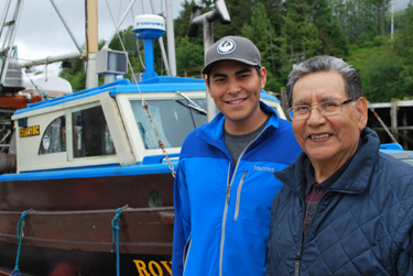
James Russell (left) and Clarence Nelson
Chief Sm’ooygit Niist’oyx, or “Grandfather Handshake”, is a hereditary chief of the Gitwilgyoots tribe, one of the nine allied tribes of the Coast Tsimshian who live near the lower Skeena River on B.C.’s north coast. His given name is Clarence Nelson. He is a traditional and commercial fisherman, a member of many community committees and a well-read lover of local, First Nations and maritime history. He is also proud to be a mentor of young people who are interested in learning to fish for a living.
Since before contact, Nelson’s people have lived in the region close to what is now known as Prince Rupert. Every summer they travelled to prime fishing and hunting grounds and returned to the village of Metlakatla for the winter. “Metlakatla had its own First Nations name –Tbuunom Galtsap. It means ‘place of plenty’. When you lived there you never ran out of food,” Nelson says.
Today the resources provided by the land and the sea are still very important to the First Nations people of Metlakatla. Nelson says marine planning helps to identify the type and location of the different sea resources and habitats and which ones might require protection. He refers to abalone, which hasn’t been harvested for many years. “My grandchildren haven’t had a taste of abalone. They can only see it in a picture. And if we don’t manage the rest of the resources, that’s what’s going to happen to everything,” he says.
For Nelson marine planning is “… for future generations, my grandchildren, so at least they’ll get an opportunity to eat what I’m eating today.”
Nelson’s grandson, James Russell, recently graduated from Vancouver Island University with a degree in Natural Resource Protection. Now he works with Lax Kw’alaams natural resource department in Port Simpson. His grandfather proudly explains the history of Russell’s First Nations name, Wiihoon, which means ‘plentiful or big fish, abundance’: “He’s from the Nagunaks tribe, the undersea world. He was given the hereditary name because he loves being on the water and fishing all the time.”
It is a challenging and changing time for young people on the North Coast. As new developments bring different opportunities, it’s even more important to remember and protect the traditional way of life.
“We’re trying to find a happy medium where we can take advantage of future opportunities and keep on going with what we’ve been doing for generations,” Russell says.
Haida Gwaii Marine Plan
The Haida Gwaii Marine Plan provides recommendations on five activities for economic development on Haida Gwaii including a community-based fisheries economy based on sustainable wild fisheries.
Haida Wild – Building a premium brand on care of customer and catch
![]()
When Debbie Beemer and Ray Stephens sold their small, successful seafood processing and smoking business to the Haida Enterprise Corporation (HaiCo) in July 2012, they found a buyer that would protect and build on the fine reputation they had established over ten years of operation in Masset on Haida Gwaii.
HaiCo chief executive officer Kevin Ainsworth described Beemer’s and Stephen’s company as a well-run business that operated seasonally from June through mid-October. It was known for its customer care, attention to detail and high-quality products. The company processed sport fish from fishing lodges and added commercially caught product when possible. “We realized that the company at the time was highly scalable, hence the expansion that we’re undergoing now,” Ainsworth said.
Now branded as Haida Wild, the seafood processing company is one of three business streams managed by HaiCo. The Haida Nation incorporated HaiCo in 2009 with the mandate to improve the economic, social, cultural and environmental well-being of the Haida and to create future opportunities on Haida Gwaii. The other businesses include a forestry operation and fishing lodges.
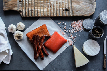
Haida Wild candied, hot smoked and cold smoked salmon
While caring for loyal customers and maintaining quality, Haida Wild plans to increase its production to include catch from HaiCo’s recreational lodges as well as fish caught by Haida Nation commercial fishery licenses. As Ainsworth said, this will result in “a nice vertical integration strategy.” In addition, as production capacity, allows the company will buy more from local commercial and recreational fishermen.
To achieve its growth goals, Haida Wild recently has expanded its facility to add a second processing line and a separate new 2,000-square-foot smoking facility. The expansion more than doubles Haida Wild’s capacity and allows the company to increase production of commercially caught fish, extend its season by three to four months and hire an additional 10 people.
Haida Wild processes Ocean Wise-certified wild fish caught in Haida Gwaii waters. The operation processes salmon, sablefish, halibut and ground fish, and is considering adding prawns, scallops and crab. Smoked products include smoked salmon, lox, candied salmon and possibly tuna in the future.
“The key this year is to see the efficiencies of the expansion and to maintain the high quality,” Shawn Baybutt, general manager of Haida Wild said. In addition, the company is building its website, designing new product labels and developing a marketing plan.
The location of the plant is an advantage as well: right across from the dock in Masset harbour. Baybutt said that because of their Masset-based facility, Haida Wild is able to “purchase direct from the fish boats. So essentially we’re on the fishing grounds. The fish comes to us and within hours it’s cut and vac-pack frozen which creates a fresher product.”
Early marketing efforts, even before the launch of a website, show promise. For the last two years, an independent grocery company with stores in Trail and Rossland has sold Haida Wild product. “They started out with a limited amount (of mostly filleted vac-packed salmon),” Baybutt said. “And last year they came up, did a fishing trip and toured the plant, then increased their order fivefold. And they’re looking to do even more this year.”
Market expansion possibilities include grocery chains in Metro Vancouver and elsewhere in B.C. The company also is exploring connections in Germany and France and hopes to introduce online direct sales in the future.
Learn more about Haida Wild.
Central Coast draft Marine Plan public review begins
The Central Coast draft Marine Plan is now available for public review and comment. To review the draft plan, learn about community meetings in Bella Coola and Shearwater and provide comments, please visit Central Coast Draft Plan for Input. The public review period runs to July 11, 2014. To learn more about the Marine Plan Partnership, watch the MaPP video.
Haida Gwaii draft Marine Plan public review period extended to May 21, 2014
The public review period for the Haida Gwaii draft Marine plan has been extended to May 21, 2014.
The Haida Gwaii planning team appreciates the interest and feedback it received from all those who attended the public and stakeholder meetings held on Haida Gwaii from April 14-17, 2014.
The draft plan and supporting background documentation, including a shorter plan summary, continue to be available online. Learn more.
In addition, people can visit the MaPP marine planning portal to review the Haida Gwaii draft spatial plan and provide comments. The marine planning portal also allows users to explore the many data layers, learn about the ecology of the MaPP study area, and better understand the variety of uses and activities in this marine environment.
North Coast draft Marine Plan public review begins
The North Coast draft Marine Plan is now available for public review and comment. To review the draft plan, learn about community meetings in Prince Rupert and Kitimat and provide comments, please visit North Coast Draft Plan for Input. The public review period runs to June 3, 2014. To learn more about the Marine Plan Partnership, watch the MaPP video.
We also welcome comments on the Haida Gwaii and North Vancouver Island draft Marine Plans, which are available for public review until May 7, 2014 and May 15, 2014 respectively. A draft marine plan for the Central Coast MaPP sub-region will be made available for public review in the coming weeks.