

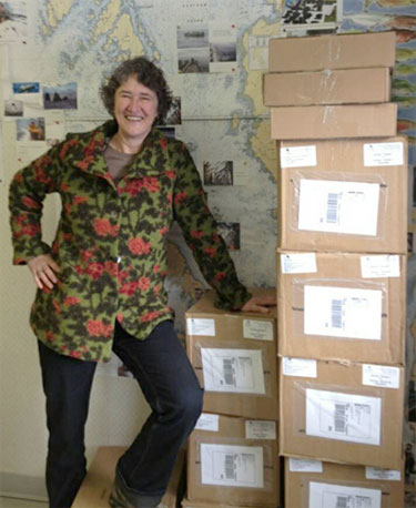
Rina Gemeinhardt with boxes of paperwork from one project referral
Rina Gemeinhardt’s work towers over her. The eight-foot stack of boxes in the Kitsumkalum First Nation referrals office contains paperwork for just one stage of one project. It’s only one of some 20 marine- or land-use applications that are referred each month to the Kitsumkalum by the Province of British Columbia and proponents.
With traditional territory that includes Terrace and Prince Rupert, the Kitsumkalum are responding to some 14 major projects underway or proposed in the North Coast region, several of them related to LNG development.
Back in fall 2012, when Gemeinhardt started her job as referrals and consultation specialist, she was shown an empty office with a computer but no digital or hard-copy records. She quickly realized she needed to establish a system to record and catalogue all the new referrals-related activity. With many project proposals in the works, a requirement to track engagement and a wide spectrum of people involved in the process including chiefs, counselors, colleagues and community members, she needed help with information management.
Enter Cedar, a web-based software program spearheaded by Coastal First Nations to address First Nations’ information management related to the referrals process.
Referrals come from provincial ministries or agencies and relate to development applications on Crown land that may have an impact on a First Nation’s territorial land or resources. Areas of impact could involve archeological sites, ecological sensitivities, traditional uses or economic benefits.
A development application could involve anything from a bike trail to marine dredging to a major infrastructure project. First Nations response could be a quick “no concerns here” or could involve commissioning reports from technical experts, conferring with other First Nations with overlapping territories and/or back and forth with the Province or project proponent.
Cedar helps staff log, analyze and respond to Crown land referrals and keeps track of email, mail and phone correspondence. It was developed by GeoMemes and piloted by the Metlakatla First Nation where it has created efficiencies in organization, tracking and filing. The Cedar program continues to evolve to address First Nations’ needs.
“Our chief was obviously hugely busy, especially with this LNG stuff,” explains Gemeinhardt. “So he said, ‘What I really need is a button.’” So the programmers developed a Chief Dashboard. “It helps somebody who is not super tech savvy and who needs condensed, up-to-date information,” she explains. “So, now the Chief’s Dashboard is where our chief can go to easily drill down for information on a specific project, or quickly get a summary.”
In addition, because the program is a collaborative, web-based tool, several people can work on it at the same time with secure access from remote locations.
The latest version of Cedar will include a spatial or mapping component. This will allow referrals offices to produce maps to illustrate data that might be important to an application such as proposed marine protected areas. The MaPP Marine Planning Portal has over 250 data layers the may help to populate this iteration of Cedar.
When Cedar first arrived in her office four months ago, Gemeinhardt was a little overwhelmed at the prospect of learning a new program, getting buy-in from all potential users and hiring and training someone to input the data. But that feeling has passed. “Now it’s just excitement,” says Gemeinhardt. “I’m thinking, oh man, this could be built upon and built upon and totally made to fit us.”