Author: adminMaPP


Haida Gwaii Slide 1

North Vancouver Island MPAC Meeting #8 – Nov 21-22, 2013

Haida Gwaii MAC Meeting #10 – June 3–5, 2013

Haida Gwaii MAC Meeting #9 – March 26–27, 2013

Haida Gwaii MAC Meeting #8 – December 3–5, 2012

Haida Gwaii MAC Meeting #7 – September 11–13, 2012

Haida Gwaii MAC Meeting #6 – May 28–30, 2012

Haida Gwaii MAC Meeting #5 – March 13–15, 2012

Haida Gwaii MAC Meeting #4 – January 30–February 1, 2012

Haida Gwaii MAC Meeting #3 – December 5–7, 2012

Haida Gwaii MAC Meeting #2 – October 27–29, 2011

Haida Gwaii MAC Meeting #1 – September 12–13, 2011

Salmon Production
Salmon production accounts for 40% of all seafood production in B.C. and salmon products generate about 53% of the total wholesale value of all B.C. seafood.

MaPP initiative partners present at two international marine planning conferences
 MaPP initiative partners attended two international conferences in October to learn from peers in the global marine planning community and to share some of the ground-breaking work underway in the MaPP initiative.
IMPAC3
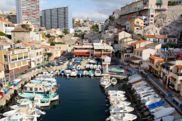
MaPP representatives presented at the International Marine Protected Area Congress 3 (IMPAC3) in Marseille, France in October 2013. The IMPAC meets every four years and brings together marine stakeholders from around the globe to assist in the conservation and sustainable development of the world’s oceans.
Two Marine Coordination Team (MCT) members attended the meeting to make presentations and attend workshops. Charlie Short (Province of British Columbia) and Steve Diggon (Coastal First Nations –Great Bear Initiative) participated in a workshop on marine protected areas (MPAs). They presented modeled spatial scenarios for protection areas that were developed in collaboration with the British Columbia Marine Conservation Analysis (BCMCA). The scenarios help MaPP to identify high-priority conservation areas to inform spatial zoning in the MaPP initiative’s four sub-regions.
The MaPP team members also took part in a session to discuss ocean zoning and the initiative’s ecosystem-based management (EBM) approach where they learned about challenges and lessons from other regions around the world. Short says, “Many countries are struggling with similar issues around governance, science, and stakeholder and public participation.”
Short and Diggon also met with experts and leaders who, like the MaPP team members, consider the ecological, social, cultural and economic aspects of marine protection.
“MaPP seems to be on the leading edge of marine spatial planning and MPA identification,” says Short. “There was a lot of interest in the MaPP process and the techniques we are using.”
North Pacific Marine Science Organization
Matthew Justice, MaPP MCT (Province of B.C.) and North Vancouver Island sub-region co-lead, and MaPP science coordinator Jo Smith, Ph.D. presented at the North Pacific Marine Science Organization (PICES) conference held in Nanaimo from October 16-18, 2013.
PICES is an intergovernmental scientific organization, formed in 1992, to promote and coordinate marine research in the North Pacific and adjacent seas. At the annual conference, scientists, managers and policy makers met to discuss recent advances in oceanography, fisheries, and marine mammal and bird populations, as well as management topics such as indicators, pollutants and communication.
The MaPP representatives presented an overview of the planning process. They also described the methods being used to develop ecosystem-based management (EBM) indicators in a collaborative project with West Coast Aquatics and Andrew Day of Uuma Consulting Ltd. The EBM indicator work is important for implementing MaPP marine plans, monitoring progress and achieving plan objectives.
Science coordinator Jo Smith says, “Developing indicators is a hot topic right now. MaPP is part of this larger global effort to assess and monitor the state of the oceans and develop indicators for human well-being in coastal and marine areas.” The conference was an opportunity for the MaPP initiative to discuss its EBM indicator development with colleagues working on similar projects in different geographies.
Smith says, “The MaPP EBM indicator work is leading the way by simultaneously developing ecological and human well-being indicators for B.C.” At the same time, she says that the MaPP initiative is learning from quantitative research on high-level indicators and ecological risk assessment models done in Alaska, Puget Sound, Georgia Strait and the California Current Ecosystem.

Resident Killer Whales
There are roughly 250 northern resident killer whales, 300 transient killer whales and 2,000 humpbacks along the B.C. coast – and increased appearances by the second largest animal on the planet, the impressive fin whale.

First Nations Population
Prince Rupert has the highest First Nations population percentage of any municipality with a population of 5,000 or more in Canada.

Prince Rupert
Prince Rupert is an island community and Canada’s wettest city. It is located on Kaien Island and linked by a short bridge to the mainland.

Bears Catching Salmon
In daytime, spirit bears are 30% more efficient than their black-coated relations at catching salmon. At night, black bears have a slight advantage. Scientists speculate that salmon are less wary of a white object above the water than a black one.

Sea Cucumbers
Sea cucumbers, particularly their eggs and young larvae, are prey for fish and other marine animals. Approximately 30 species are found on B.C.’s west coast.


