

 It’s hard to plan for something you hope will never happen, and yet being prepared for a crisis increases the chances of managing an emergency efficiently and equitably.
Today on the coast there is significant marine traffic, and with that traffic come risks. Yet at the same time, this traffic helps generate economic activity and jobs up and down the coast. It is critical to ensure that this traffic stays safe and that there are plans in place should an accident happen.
For coastal communities, one way of getting prepared could mean developing a geographic response plan (GRP) – a plan that can kick into action within the first hours of an incident, often well before emergency response agencies can get to the scene. GRPs consider the multiple priorities of coastal communities – social, cultural, ecological, and economic.
Because GRPs pre-identify priorities such as areas for protection, location of human and equipment resources, and places of refuge for troubled vessels, they can accelerate response time and help to reduce the threat and impacts of an incident.
One deliverable of the MaPP initiative is to help communities in the MaPP study area understand and define the nature and scope of GRPs. The initiative has contracted environmental emergency response planner Stafford Reid to begin the work. “Geographic response plans are part of coastal planning management – a tool for managing the impacts from all types of vessels and all types of cargo,” Reid says.
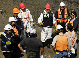
The tough work in emergency response planning is determining the priorities for first responders. What gets first attention – a cultural heritage site, environmentally sensitive habitat, or a business? The process needs to be collaborative, transparent and considerate of diverse possibilities, since trade-offs are inevitable and difficult decisions have to be made. And in the moment of a crisis, there is little time for discussion.
Graham Knox, director of the Environmental Emergencies Program with the B.C. Ministry of Environment, says, “If we can do this sort of work up front, then the first responders can hit the ground running in that first 24- to 48-hour period, while the cavalry gets mustered and until the Incident Command Post and the incident management teams are in place.”
The Incident Command Post integrates many response teams, including Canadian Coast Guard, Fisheries and Oceans Canada, Environment Canada, Ministry of Environment, First Nations and local government, as well as the ship owner and its contracted response organization.
“In the field of emergency management, all emergencies start at the local level. So, it’s critical that local people are engaged and included in all phases of preparedness through response and recovery,” Knox says. “First Nations and other people living in the coastal communities have a lot of information that more centralized agencies may not have.”
GRPs, which are well developed in the United States, have evolved from hard-copy documents to web-based, multi-media applications that include geographic information systems, databases, documents, images and videos. GRP design and development is new to Canada.
The MaPP initiative has compiled a suite of studies and datasets that could support GRP development, not to mention the wealth of on-the-ground knowledge and expertise in coastal communities. In addition to the draft marine plans, MaPP resources include traditional, local and scientific knowledge, technical expertise and mapping/planning tools such as the marine planning portal with over 300 data layers.